Collaboration of the Exodus Path by NASA
satellite.
Also see
http://www.biblebigpicture.com/biblelessons/evidenceofredseacrossing.htm
http://www.arkdiscovery.com/red_sea_crossing.htm
http://www.wyattmuseum.com/red-sea-crossing.htm
for more pics
More detailed version - Iraqi war surprise
Crossing the RED SEA by Don Kopp
It's 1:30 a.m., February 12, 1991. Twenty-five thousand feet below the
A10 Warthog lies the Iraqi desert, chilled to a temperature of 25° F. The
A10 rolls out from its lofty perch, silently dropping to an attack altitude
of less than 250 feet off the desert floor. The pilot flicks on the infrared
gunsite and arms the awesome 30mm gauttling gun. He mutters to himself,
"Yep, there they are, lined up like a shopping mall parking lot."
Six months prior to this encounter, Saddam Hussein parks 1,500 heavy tanks
on the border between Iraq and Saudi Arabia. Hussein has crushed the tiny
oil-producing country of Kuwait and now appears ready to invade the
oil-producing giant with which it shares a common border.
Alarmed by ominous signs of another invasion by the Iraqi strongman, the
United States responds by deploying its elite 32nd Airborne Division to
Saudi Arabia. Saddam Hussein continues to threaten the Allies with "the
mother Of all wars" as he steadfastly builds and reinforces his huge
military
machine along the Saudi border.
By mid October it is discovered that Iraq has been burying these heavy tanks
in the sand, leaving only the gun turrets sticking out. It is Saddam's
intention to use these tanks, spread out along the Saudi border, as a line
of artillery. By camouflaging the guns and turrets sticking above the
ground, Iraq effectively made these units invisible from the air and any
ground surveillance units.
November 1990, America shifts its Keyhole-satellite into position over the
Iraqi desert. The 55-feet-long, 12-ton spy satellite takes pictures of the
cold desert floor during the twilight hours. "Big Bird," as the ground
crews
call it, has infrared scanners capable of detecting a temperature difference
of only 1/2 degree from its lofty perch of 155 miles.
Originally designed to detect underground missile silos (a silo's
temperature is slightly warmer than the surrounding earth), it was placed into
position to take pictures of the buried tanks. The tanks would heat up during
the
hot daylight hours and continue to hold heat long after the rest of the
desert cooled during the night. The buried tanks showed up on the satellite
photo like neon signs. The exact location of each tank was then plotted on a
target map and given to American and British pilots who systematically
eliminated them.
However, Big Bird photographed more than buried tanks. To everyone's
amazement, a thin red line (heated areas show up as red on infrared photos)
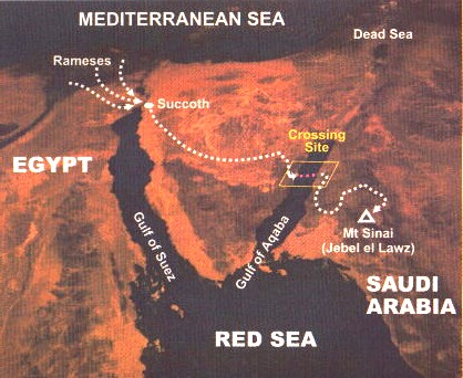
coming from the ancient site of Rameses in the Land of Goshen (Egypt),
ran eastward, skirting the East Side of the Red Sea. "So God led the
people around the desert road toward the Red Sea" (Exodus 13:18).
The line went first to Succoth, lying just northeast of Rameses. It was
Here the children of Israel, as they left Egypt, first stopped and
Collected the bones of Joseph (Exodus 13:19, 20). The line then extended
onward to Etham, and then over the high plateau of the Sinai Peninsula,
finally dropping down onto what is today called The Gulf of Aquaba, the
easternmost finger of the Red Sea.
One need only look at map of this area to realize that the children of
Israel were now trapped. In front of them was the Red Sea Coming from behind
them to the northwest was Pharaoh's army. They had been led by God Himself into
what appeared to be a trap.
But, the thin red line emerged from the east side of the Red Sea and
continued onward, eventually ending up in present day Saudi Arabia at the
foot of a 3,465 foot mountain known as "Jabal al Lawz" (Mountain of
God)-the
real Mount Sinai!
The satellite photo team stared incredulously at the photo! A red line, as
if drawn by God's own finger, traced the exact route of the exodus. When the
Gulf war finally ended, archeologists went back into the region to discover
how it was possible for a 3,500-year-old trail to exist well enough to show
up on satellite photos.
They found that a million plus people, with all their livestock, pulverized
the desert sand into a fine, flour-like powder. During the desert nights,
the humidity rises to levels of near 100%, thus wetting the powdery sand,
making a concrete-like substance. Through the years, this highway was buried
by shifting sands, protecting the trail from the elements. During the day
it would heat up like the tanks, and being more dense than the surrounding
sand, continue holding the heat longer into the cold nights! A coincidence?
Not even!
Remember what God told Moses to say to Pharaoh 3,500 years ago, "But
Indeed for this purpose I have raised you up, that I may show My power in
you, and that My name may be declared in all the earth"
(Exodus 9:16 NKJ).

IRAQ
WAR SURPRISE
What
a shrewd man! During the first Gulf War, Saddam Hussein had 1,500 heavy tanks
positioned on the border between Iraq and Saudi Arabia.
But
he buried them in the sand, leaving only the gun turrets sticking out. These
were well camouflaged, effectively making them invisible from the air and any
ground surveillance units. Bad luck! They got discovered. So America shifted its
Keyhole satellite into position over the Iraqi desert.
Then
the 55-feet-long, 12 ton spy satellite took pictures of the cold desert floor
during the twilight hours. And do you know, “Big Bird”, as it was called,
had infrared scanners which, from 155 miles above the earth, could detect a
temperature difference of only half a degree.
So
now the satellite was placed in position to take pictures of the buried tanks.
You see, the tanks would heat up during the hot
daylight hours and continue to hold heat long after the rest of the desert
cooled during the night.
Well,
the buried tanks showed up on the satellite photo like neon signs. The exact
location of each tank was then plotted on a target map and given to allied
pilots who systematically eliminated them.
SATELLITE
DISCOVERY THEN STARTLES SKEPTICS
However,
Big Bird photographed more than buried tanks. It made a discovery that blew
skeptics out of the water. (We’ll come back to what this satellite found, in a
just few minutes.)
Of
course, you’ve heard the story of Moses who led the escape of the Hebrew
slaves from Egypt, and the drowning of Pharaoh’s pursuing army in the Red Sea?
If
you didn’t know, that particular story is often attacked by critics. Before
the Iraq war, while divers were searching for possible remains of this event, a
professor Laughed his head off. With a mile of letters after his name, this
clever man assured us emphatically us that the biblical Exodus, the chase across
the Red Sea, and the drowning of Pharaoh's army “never happened.”
Poor
guy! He missed the greatest underwater discovery of the century.
Skeletal
remains of horses, soldiers, chariot cabs and wheels, were found, all mixed
together and scattered over the sea bed of the Gulf of Aqaba. Yes, here was a
huge army of remains. Six-spoked wheels, 4-spoked wheels and 8-spoked wheels.
SKEPTICS
SAID: “WRONG LOCATION”
But
the location also ruffled some feathers. According to the Bible account, the Red
Sea parted and the Hebrews escaped on a dry sea bed to the opposite coast, but
when Pharaoh’s army pursued, the sea rolled back from both sides and drowned
every last one of them.
"But
the Gulf of Aqaba" is not the Red Sea," shouted another skeptic.
"So your find is in the wrong place."How would you respond to that?
Well,
you may already know that the Red Sea separates Africa from Arabia, then splits
into two fingers – the Gulf of Suez in Egypt, and the Gulf of Aqaba between
Egypt and Saudi Arabia. Some have assumed that if the event occurred at all, it
would have to be in the Gulf of Suez, closest to Egypt.
However,
that's not so! If you take the geographical details given in the Bible report
literally, they will actually lead you not to the Gulf of Suez but to the Gulf
of Aqaba – to a spot on the coast near Nuweiba. And this is the exact place
these remains were
found.
EGYPT’S
WAR CHARIOTS
The
Egyptians had war chariots in their army and these, together with all the
Egyptian chariots, were used by the Egyptian army when they pursued the people
of Israel.
“And
he made ready his chariot, and took his people with him: And he took six hundred
chosen chariots, and all the chariots of Egypt, and captains over every one of
them.” (Ex. 14:6-7) The first century historian Flavius Josephus mentions the
same number of chariots, as well as the fact that there were 50,000 horsemen and
200,000 infantry soldiers.
These
war chariots were intended for quick battles and often had two soldiers: one who
drove the chariot and one who fought from the chariot with bow, arrow and sword.
These chariots were relatively light. The body work (or chariot basket) was made
of wood and leather. The flooring was of wood, and the wheel axle was fastened
to the underside of the floor. The wooden shaft leading to the horses (of which
there were two) was also attached under the floor.
DATING
THE WHEELS
However,
could these wheels we found on the sea bed be from some event other than the
Exodus?All right then, what can we discover from the wheels? Do the wheels tell
us anything about the date of the event which caused them to end up there?
Would
you believe, the number of spokes helps us arrive at a precise answer.
(a)
The 4-spoked wheels were used from the early period of the 18th dynasty until
the time of Thutmoses IV.
(b)
The 8-spoked wheels can be seen on the chariot bodies of Thutmoses IV’s war
chariots, and are considered to be a short-lived
experiment during a brief spell of his reign. This was the only time in Egyptian
history that 8-spoked wheels were ever used.
(c)
After Thutmoses IV, only 6-spoke wheels were used. However, these were already
used sometimes during the reign of Thutmoses IV.
This
establishes the date of the wheels discovered on the seabed (4-spoke, 6-spoke,
and 8-spoke wheels) as within a limited period – a date during part of the
18th dynasty, most likely during the reign of Thutmoses IV – around 1450 BC
Several
different varieties of chariots and wheels were to be expected at the Exodus,
since all the chariots in Egypt were mobilized. (Ex. 14:7) According to biblical
chronology (compared to known historical dates) the Exodus took place about 1446
BC. This agrees well with the wheel dating.
STARTLING
SATELLITE CONFIRMATION
But
I must tell you about the most amazing Gulf War satellite discovery. You see,
Big Bird photographed more than buried tanks in Iraq. It made a discovery that
blew skeptics out of the water.
As
we noted, critics have said for years that the Exodus never happened. And others
claimed that it did, but that the exodus crossing took place in the Gulf of
Suez.
Now,
get this! When the satellite photo team examined pictures from that satellite
high in the sky above the Middle East… and turned their attention to Egypt…
To
everyone’s amazement, a thin red line (heated areas show up as red on infrared
photos) was seen running eastward from the Nile Delta (the ancient land of
Goshen referred to in the biblical book of Exodus). It ran eastward, skirting
the east side of the
Red Sea. The book of Exodus states that the escaping Hebrew slaves in Egypt
travelled “around the desert road toward the Red Sea. (Exodus 13:8)
Well,
the satellite photo team examined this red line with interest. From the Nile
Delta, they noticed that the line went first a little eastward to Succoth.
According to the book of Exodus, it was at Succoth that the Israelite slaves, as
they left Egypt, were marshalled into ranks for the journey ahead.
The
line then extended over the high plateau of the Sinai Peninsula, finally
dropping down onto what is today called the Gulf of Aqaba, the easternmost
finger of the Red Sea.
Was
this the route of the Exodus?
If
you look at a map of this area, it will appear that, if so, the Hebrews were led
into a trap, with the sea in front and the rugged mountains behind them, through
which the pursuing army of Pharaoh came after them. But the thin red line
emerged from the east side of the red Sea and continued into the present day
Saudi Arabia at the foot of the high peak known as Jebel el Lawz – the real
Mount Sinai!
The
satellite photo team stared incredulously at the photo. A red line, as if drawn
by God’s own hand, traced the exact route of the Hebrew Exodus. The red line
entered the sea at Nuweiba on the Gulf of Aqaba, and emerged again on the other
side in Saudi Arabia. And get this - the sea area in between thesetwo red lines
is precisely where our teams discovered the Egyptian chariot and skeletal
remains.
GROUND
EXPLORATION OF THE RED LINE ROUTE
When
the Gulf War finally ended, archaeologists went back into the region to discover
how it was possible for a 3,500 year old trail to exist well enough to show up
on satellite photos. They found that 3 million people, with all their livestock,
pulverised the desert sand into a fine, flour-like powder. During the desert
nights, the humidity rises to levels near 100%, thus wetting the powdery sand,
making a concrete-like substance. Through the years, the highway was buried by
shifting sands, protecting the trail from the
elements. During the day it would heat up like the Iraqi tanks, and being more
dense than the surrounding sand, continue holding the heat longer into the cold
nights!
A
coincidence? Forget it!
An
interesting 3,500 year old prophecy in Exodus states: “But indeed for this
purpose I have raised you up, that I may show my power in you, and that My Name
may be declared in all the earth.” (Exodus 9:16)
This
event was so spectacular – unlike any other in history – that it has been
the subject of famous paintings and Hollywood epics, such as “The Ten
Commandments”, starring Yul Brenner and Charlton Heston. This historical event
of 3,500 years ago has,
indeed, been declared in all the earth – just as the ancient prophecy said it
would!
back
to dogpage